

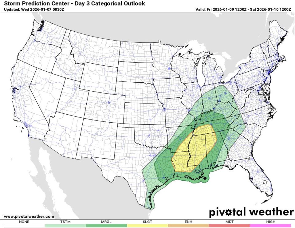
NORMAN, Okla. — The Storm Prediction Center has escalated its severe weather outlook for Friday, January 9, placing portions of the Mid-South, ArkLaMiss, and Southeast under a Slight Risk (Level 2 out of 5)—an increase from Thursday’s Marginal Risk—reflecting growing confidence in an organized severe thunderstorm event.
The threat window opens late Friday afternoon and peaks into the evening and overnight hours as a potent surface low deepens and tracks from the Southern Plains toward the Ohio Valley.
Affected Areas
The Slight Risk area stretches from eastern Texas and Louisiana (ArkLaMiss region) eastward through central and northern Mississippi, western Tennessee, and into parts of Alabama and Kentucky. Cities potentially impacted include Shreveport, Jackson, Memphis, Tupelo, and Birmingham.
Key Ingredients Driving the Risk
- Moisture: Rich Gulf moisture surges northward, pushing surface dew points into the lower to mid-60s—plenty of fuel for robust thunderstorm development.
- Wind Shear: Strong deep-layer shear combined with a strengthening low-level jet Friday evening will promote storm organization and rotation.
- Lift: The approaching low-pressure system provides widespread ascent needed to ignite storms.
Limiting Factors
- Cloud Cover & Early Rain: Extensive clouds and pre-frontal showers could limit daytime heating, capping instability and potentially reducing overall storm intensity.
- Storm Mode Uncertainty: Multiple rounds of precipitation may lead to clustered or linear storms rather than discrete supercells, influencing whether damaging winds or tornadoes dominate.
Primary Threats
- Damaging wind gusts — the most widespread concern.
- A few tornadoes — possible, especially where discrete storms can develop.
- Hail — some large hail likely, particularly southwest portions where instability may peak.
Bottom Line
Friday’s setup features a more classic severe weather environment than recent days, with strong dynamics overcoming modest instability. While not a high-end outbreak, the combination supports scattered severe storms capable of producing damaging winds and isolated tornadoes, mainly Friday evening into the overnight hours.
Residents in the risk area should review severe weather plans, keep multiple ways to receive warnings (wireless emergency alerts, NOAA weather radio, trusted apps), and stay weather-aware as details evolve.
Continue monitoring the Storm Prediction Center (spc.noaa.gov) and your local National Weather Service office for the latest watches, warnings, and refined outlooks. This event remains fluid—changes in cloud cover and instability could shift the severity potential up or down.
