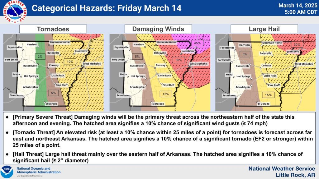
LITTLE ROCK, Ark. — A tornado watch is in effect across parts of Arkansas until 11 p.m. tonight, signaling a tense day of weather threats that could unleash large hail, damaging winds, and twisters. Forecasters warn that if storms ignite, they’ll tap into an unstable atmosphere, with north, northeast, and east Arkansas most at risk this afternoon and evening once a stubborn cap of warm air breaks.
The potential for severe weather hinges on storm development, but the stakes are high. Meteorologists highlight a volatile setup—once triggered, any storms could spin up fast and hit hard. Beyond the thunderstorm risks, strong gradient winds are set to sweep statewide, with wind advisories and high wind warnings flagging areas prone to powerful gusts outside of storm activity.
West and northwest Arkansas face an added wrinkle: bone-dry air mixing with those fierce winds has sparked a red flag warning, elevating fire danger to critical levels. The overlapping hazards—tornadoes, winds, and fire risk—demand heightened vigilance through tonight.
More counties, likely in central, southern, and eastern Arkansas, could soon fall under an expanded watch as conditions evolve. Radar is under close scrutiny, with hints that a rare Particularly Dangerous Situation (PDS) watch might be issued for eastern counties if the threat ramps up tonight. Reserved for the most extreme tornado scenarios, a PDS watch would underscore the growing peril as instability peaks after dark.
While the current watch remains serious, experts suggest the setup could turn even more favorable for severe storms in the east by evening. Residents are urged to stay alert, keep weather updates handy, and brace for a turbulent stretch ahead.